
Aberdare Waterfalls, Moorlands, Forests and Hiking Routes
Choose Karuru, Gura, Chania, Magura, Dragon’s Teeth, Mount Satima or a southern peak with the right gate, vehicle, guide, clothing and weather margin.
- Read the Aberdares as four connected landscapes
- The route map in one table
- Karuru Falls
- Gura Falls
- Seeing Karuru and Gura together
- Chania Falls
- Magura Falls and Queen’s Cave
- Other streams and unnamed cascades
- Waterfall conditions after rain
- The high moorlands
- Dragon’s Teeth
- Mount Satima
- Mount Satima route stages
- Altitude is not a fitness test
- A shorter Satima day to Dragon’s Teeth
- Elephant Hill
- Rurimeria
- Table Mountain in the Aberdares
- Mount Kinangop
- Forest walks
- Bamboo zone
- Mau Mau Post Office tree
- Wildlife along scenic routes
- Birding across altitude bands
- Best time for waterfalls
- Best time for hiking
- Grade the day by more than distance
- Build a weather decision tree before leaving
- Food and water for a full mountain day
- What to wear
- What to carry
- Ranger and guide arrangements
- Choosing the right gate
- Road to trailhead
- Photography at waterfalls
- Photography in mist
- Family-friendly scenic routes
- Hiking with limited mobility
- One-day waterfall itinerary
- Two-night waterfall and moorland itinerary
- Two-night Mount Satima itinerary
- Three-night active itinerary
- Combine Aberdare hiking with Mount Kenya
- Combine waterfalls with Solio or Laikipia
- Common mistakes
- Compare two hiking quotations
- Frequently asked questions
- Let the route be the destination
- Sources and further planning
The Aberdares do not reveal themselves in one view. A road begins beneath tall forest, passes through bamboo and climbs into an open world of tussock grass, giant plants and dark volcanic rock. Rivers gather in the high country, then fall into ravines so deep that one waterfall can be seen across the gorge from another.
This is why the park deserves more than a list of attractions. A useful guide to Aberdare waterfalls, moorlands, forests and hiking routes must connect Karuru Falls, Gura Falls, Chania Falls, Magura Falls, Mount Satima, Dragon's Teeth and the southern peaks to the correct gate, road, walking plan and weather margin. This guide explains the landscape one route at a time.
Use the Aberdare entry fees, gates and road conditions guide before fixing any trailhead.
Read the Aberdares as four connected landscapes
| Landscape | What it feels like | What it asks from the visitor |
|---|---|---|
| Lower montane forest | Dark trunks, fern, birds and hidden mammals | Quiet, patient driving and walking only where permitted |
| Bamboo belt | Dense green cover and narrow sight lines | Guide knowledge and realistic wildlife expectations |
| High moorland | Wind, tussock, bog, giant lobelia and wide sky | Warm waterproof clothing and strong navigation |
| Ravines and waterfalls | Sudden cliffs, spray and long drops | Safe viewpoints, time and respect for wet edges |
The route map in one table
| Experience | Broad sector | Typical format | Main caution |
|---|---|---|---|
| Karuru Falls | Central high country | Drive plus viewpoint walk | Road and fog |
| Gura Falls | Across the gorge from Karuru | View from the Karuru area | Distance and cloud |
| Chania Falls | Southern or central waterfall circuit | Drive and shorter walk | Current access road |
| Magura Falls and Queen's Cave | Forest waterfall circuit | Guided scenic stop | Wet rock and local route |
| Mount Satima | Northern moorlands | Full hiking day | Altitude and bog |
| Dragon's Teeth | Mount Satima route | Shorter highland hike | Weather and trailhead road |
| Elephant Hill | Southern Aberdare Range | Steep full-day hike | Fitness and descent |
| Rurimeria | Southern high country | Long hiking day | Altitude, mud and navigation |
| Table Mountain or Kinangop | Southern range | Serious mountain day | Access, distance and weather |
Karuru Falls
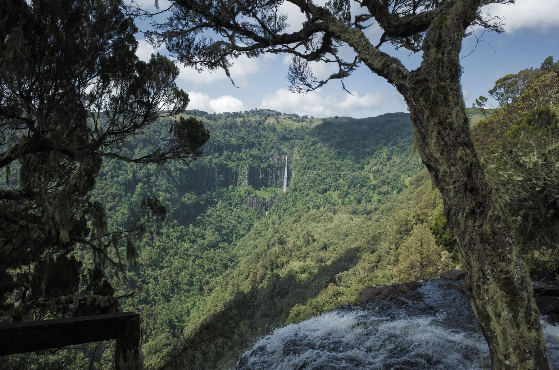
Karuru is the defining Aberdare waterfall. KWS describes its ice-cold water dropping about 300 metres through a sequence of stages into the forested gorge. The scale is difficult to read from a photograph. The river seems to disappear over one lip, reappear lower down and then fall again.
| Karuru planning point | Practical answer |
|---|---|
| Best experience | Give the viewpoint time rather than taking a quick roadside picture |
| Vehicle | Proper 4×4 for the current park road |
| Weather | Cloud can hide the lower stages; wait only within the day's safety margin |
| Footwear | Grippy shoes for wet ground |
| Photography | Wide lens for the gorge and telephoto for lower tiers |
Gura Falls
Gura falls from the opposite side of the same vast valley. It is less about standing beside the water and more about understanding the gorge as one landscape. From the Karuru side, Gura appears as a white line against distant forest when cloud allows.
| Gura condition | What changes |
|---|---|
| Clear air | The full relationship between river, cliff and forest becomes visible |
| Mist | The fall may appear and vanish repeatedly |
| Strong rain | Volume increases, but road and viewpoint access may become harder |
| Dry spell | Road may improve while the water narrows |
Seeing Karuru and Gura together
The best viewpoint story places the two falls across one gorge. Do not rush from one pin to another expecting separate car parks. Ask the gate officer which Karuru viewpoints are open and where Gura can be seen safely.
| Bring | Why |
|---|---|
| Binoculars | Read the distant Gura cliff and birds |
| Lens cloth | Spray and drizzle blur glass quickly |
| Waterproof jacket | Weather can change while you wait |
| Packed lunch | The route is remote |
| Offline map | Mobile data is not reliable |

Chania Falls
Chania offers a different scale and forest setting. It can fit a moderate scenic day when the access road is confirmed. The value lies in the river, surrounding vegetation and the transition between forest and high country, not in comparing its height with Karuru.
| Chania plan | Check |
|---|---|
| Road approach | Open and passable for the vehicle |
| Walking section | Current length and surface |
| Rain | River volume and slippery edges |
| Picnic | Approved place and waste plan |
| Combination | Whether Karuru or another stop remains realistic |
Magura Falls and Queen’s Cave
Magura cascades near the yawning entrance known as Queen's Cave. The combination feels intimate after the great open Karuru gorge. Forest shade, wet rock and river sound become the experience.
| At Magura | Safe practice |
|---|---|
| Cave edge | Follow guide and ranger instructions |
| Wet stone | Move slowly and use shoes with grip |
| Photography | Avoid stepping backwards for a wider frame |
| Wildlife | Stay alert in dense cover |
Other streams and unnamed cascades
The Aberdares hold many smaller falls, pools and streams. Some are seasonal, some are known locally and some lie beyond ordinary visitor routes. A small cascade can be beautiful without being turned into an unofficial trail.
| If a guide suggests a lesser-known fall | Confirm |
|---|---|
| Access permission | The route is approved for visitors |
| Ranger need | Required escort is arranged |
| Walk length | Distance and elevation are honest |
| Return time | The group can finish before weather and darkness |
Waterfall conditions after rain
Rain can make the falls spectacular and the approach difficult at the same time. Water volume is only one part of the decision.
| Rain effect | Benefit | Risk |
|---|---|---|
| Higher river | Stronger fall and spray | Slippery viewpoint |
| Low cloud | Atmospheric forest | Hidden gorge |
| Saturated road | Green landscape | Mud, ruts and delays |
| Wet trail | Rich colour | Poor footing |
The high moorlands
Above the forest, the Aberdares open into a landscape of tussock grass, heather, bog and giant plants. The sense of space is enormous, but the ground can be wet and the air cold. Roads and trails are exposed to wind and cloud.
| Moorland feature | How to experience it |
|---|---|
| Tussock and bog | Stay on the established track |
| Giant lobelia | Photograph without trampling plants |
| Volcanic outcrops | Use them as landmarks only with proper navigation |
| Wide valleys | Carry binoculars for distant wildlife and raptors |
| Sudden mist | Keep the group together |
Dragon’s Teeth
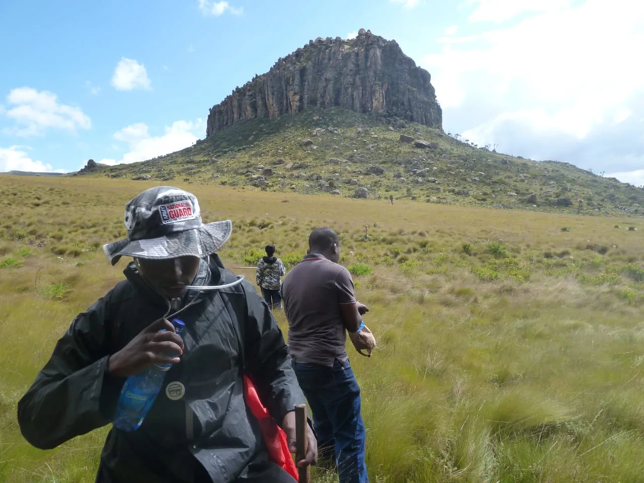
Dragon's Teeth are jagged volcanic rock formations on the Mount Satima route. They offer a satisfying shorter objective for hikers who want the high Aberdare landscape without committing to the summit.
| Dragon's Teeth option | Who it suits |
|---|---|
| Out-and-back from the trailhead | Fit walkers with limited altitude ambition |
| Photography-focused walk | Travellers who want time among the formations |
| Acclimatisation day | Hikers preparing for a higher objective later |
| Family with older teens | Only with suitable weather, footwear and pace |
One hiker wrote, “the section to Dragon’s Teeth is absolutely worth it.” The full February 2026 discussion explains why the shorter route can be rewarding for people who do not want to push to 4,000 metres.

Mount Satima
Mount Satima, or Ol Donyo Lesatima, reaches 4,001 metres and is the highest point in the Aberdare Range. KWS identifies it as Kenya's third-highest peak. The trail is not a technical climb in ordinary conditions, but altitude, bog, wind and distance make it a real mountain day.
| Satima factor | Planning response |
|---|---|
| 4,001-metre summit | Acclimatise and watch for altitude symptoms |
| Boggy sections | Waterproof boots and gaiters help |
| Open exposure | Carry shell, insulation, hat and gloves |
| Long day | Start early with food and water |
| Remote trailhead | Confirm 4×4 access and ranger meeting point |
Mount Satima route stages
| Stage | Landscape | Decision |
|---|---|---|
| Trailhead | Scrub and open ground | Check weather and group health |
| Wetland section | Bog, tussock and giant plants | Keep feet dry and pace steady |
| Dragon's Teeth | Dramatic rock formations | Turnaround option for a shorter day |
| Upper trail | Open high ground | Reassess cloud, wind and altitude |
| Summit | Wide views when clear | Leave enough time for descent |
One hiker said, “the scenery and landscape is definitely out of this world.” The complete Mount Satima review also describes the bog, Dragon's Teeth and the effect of altitude in the writer's own experience.
Altitude is not a fitness test
A strong runner can still feel headache, nausea or unusual fatigue at altitude. The correct response is to stop ascending, assess honestly and descend if symptoms worsen.
| Symptom | Response |
|---|---|
| Mild headache | Rest, hydrate and reassess before climbing higher |
| Nausea or dizziness | Stop ascent and tell the guide |
| Confusion or loss of coordination | Descend and seek urgent medical help |
| Breathlessness at rest | Treat as serious |
A shorter Satima day to Dragon’s Teeth
The shorter route keeps the most distinctive rock scenery and reduces time at the highest altitude. It is not automatically easy, because the trailhead, bog and weather remain.
| Keep | Remove |
|---|---|
| Early start | Summit pressure |
| Ranger and 4×4 | Extra upper miles |
| Full mountain clothing | Assumption that a shorter route needs no preparation |
| Turnaround discipline | Competition within the group |
Elephant Hill
Elephant Hill rises on the southern Aberdare Range and is a popular training mountain. The route climbs through plantation and forest into bamboo and open high ground. Its repeated ascent makes it physically demanding even though the summit is lower than Satima.
| Elephant Hill factor | What it means |
|---|---|
| Steep sustained climb | Train for ascent and descent |
| Bamboo zone | Mud and narrow trail are possible |
| Southern access | It is not the same gate plan as Satima |
| Popular training route | Early start still matters |
Rurimeria
Rurimeria is a high southern Aberdare hike known for long climbs, moorland and expansive views. It should be treated as a full mountain day with an experienced guide.
| Prepare | Reason |
|---|---|
| Strong hill fitness | Elevation accumulates across the route |
| Navigation | Cloud can erase obvious lines |
| Water and food | The day may extend |
| Descent reserve | Tired legs increase slipping risk |
Table Mountain in the Aberdares
Aberdare Table Mountain is distinct from the famous South African landmark. It belongs to the range's series of high peaks and plateaus. Access and trail conditions should be confirmed locally rather than inferred from a name on a map.
| Confirm | Why |
|---|---|
| Trailhead | Several local routes may exist |
| Land and park permissions | Access can cross managed areas |
| Guide | Navigation and community context |
| Distance | Online descriptions may measure different starts |
Mount Kinangop
Kinangop rises in the southern range and is one of the highest Aberdare summits. It is a serious, often wet mountain objective. Do not add it casually to a wildlife itinerary.
| Kinangop requirement | Minimum standard |
|---|---|
| Weather window | Stable enough for the route |
| Guide | Familiar with the current trail |
| Fitness | Long mountain day capability |
| Equipment | Waterproof boots, layers and navigation backup |
Forest walks
Walking in a wildlife park is different from hiking an open public trail. Elephants, buffalo and other animals use the forest. Walk only on approved routes with the required ranger or guide.
| Forest-walk rule | Reason |
|---|---|
| Never walk from the vehicle without permission | Dense cover hides wildlife |
| Keep the group together | The guide needs to manage one unit |
| Speak quietly | Hearing is part of safety |
| Do not block an animal's route | Forest wildlife needs space |
Bamboo zone
Bamboo creates one of the park's most distinctive transitions. It can also make animal movement difficult to see. Broken stems, fresh dung and distant sound may reveal more than a direct sighting.
| Look for | Interpret carefully |
|---|---|
| Fresh tracks | Direction and recent movement |
| Broken bamboo | Could indicate feeding, not an animal still present |
| Dung | Species and freshness with guide help |
| Alarm calls | A clue, not a guarantee |
Mau Mau Post Office tree
KWS identifies a large Mugumo fig known as the Mau Mau Post Office, used as a secret message point during Kenya's struggle for independence. A visit should tell that human history with respect rather than treating the tree as a novelty.
| Add to the visit | Avoid |
|---|---|
| Guide with historical context | Invented dramatic story |
| Time to observe the tree | Climbing or damaging it |
| Connection to the wider independence history | Reducing history to one photograph |
Wildlife along scenic routes
Waterfall and hiking routes still pass through wildlife habitat. Elephants, buffalo, giant forest hog, colobus monkeys and many birds may appear, but the dense setting makes sightings brief.
| Habitat | Possible focus |
|---|---|
| Salient forest | Elephant, buffalo and waterhole activity |
| Bamboo | Signs of movement and forest mammals |
| Moorland | Raptor, grassland bird and distant mammal |
| Stream | Bird calls, insects and tracks |
Birding across altitude bands
KWS records more than 250 bird species in the park. A scenic itinerary can become an excellent birding day when it slows down across forest, edge and moorland.
| Zone | Birding method |
|---|---|
| Forest canopy | Listen first, then locate movement |
| Forest edge | Watch mixed flocks and flowering plants |
| Moorland | Scan ground and sky |
| Waterfall gorge | Watch raptors and cliff movement |
Best time for waterfalls
Falls carry more water during and after rain, while access may be harder. The useful choice balances volume with road and viewpoint safety.
| Preference | Timing principle |
|---|---|
| Maximum flow | Wet period with flexible route |
| Clearest long view | Drier, stable weather |
| Green forest photography | Wet or recently wet conditions |
| Easiest road | Drier spell, still confirmed on the day |
Best time for hiking
Choose a stable forecast within a drier period, start early and keep a weather alternative. Mountain cloud can form even in a generally good season.
| Forecast | Decision |
|---|---|
| Clear morning, later cloud | Start early and descend before deterioration |
| Persistent storm | Reschedule or choose lower route |
| Heavy rain previous day | Ask about bog and road access |
| Strong wind | Reconsider exposed high route |
The best time to visit Aberdare National Park guide explains the wider seasonal trade-offs.
Grade the day by more than distance
A short Aberdare route can still be demanding when the road reaches the trailhead late, the ground is boggy and the group is not acclimatised. Distance belongs beside ascent, altitude, surface, exposure and the time needed to return through the gate.
| Route type | Physical load | Technical and logistical load |
|---|---|---|
| Short waterfall viewpoint | Usually low to moderate | Wet edges, rough road and wildlife rules |
| Dragon's Teeth out-and-back | Moderate | Bog, altitude, ranger and remote trailhead |
| Mount Satima summit | Moderate to high | 4,001-metre altitude, exposure and long day |
| Elephant Hill | High for many walkers | Steep ascent, bamboo mud and tiring descent |
| Rurimeria or Kinangop | High | Navigation, weather, distance and remote access |
Ask the guide for the route measured from the place where the vehicle will actually stop. A kilometre figure taken from a different trailhead can make the day look easier than it is.
Build a weather decision tree before leaving
The alternative should be chosen before cloud removes the original route. A lower waterfall or forest circuit may still be rewarding when a high summit is unsafe.
| Morning observation | Primary decision | Useful alternative |
|---|---|---|
| Clear, stable and trailhead road open | Begin the planned high route early | Keep the agreed turnaround time |
| High summit hidden but lower moorland visible | Walk to Dragon's Teeth if the guide agrees | Moorland photography and birding |
| Heavy rain or thunder forecast | Cancel the exposed summit | Lower scenic drive or lodge waterhole |
| Trailhead road impassable | Do not force the vehicle | Confirmed waterfall or forest route from another gate |
| Group member unwell at altitude | Stop ascending | Descend, rest and seek help if symptoms persist |
Weather flexibility is not a consolation prize. Cloud moving through forest, rain strengthening a fall and sunlight returning across wet moorland can create the most memorable photographs of the trip.
Food and water for a full mountain day
Carry food that remains easy to eat in cold wind and enough water for the actual duration. A summit picnic packed at the bottom of an overfilled bag is not useful when somebody needs energy quickly.
| Carry | Practical use |
|---|---|
| Breakfast before the trail | Starts the climb fuelled |
| Quick snacks in an outer pocket | Small regular energy without unpacking |
| Substantial lunch | Supports the descent as well as the summit |
| Water divided between bottles | Reduces the risk of one leak ending the supply |
| Warm drink where practical | Comfort during a cold stop |
| Emergency food reserve | Delay, detour or slower group pace |
Do not drink directly from a stream because the water looks clear. Carry treated water or a reliable treatment system understood by the group.
What to wear
| Layer | Purpose |
|---|---|
| Moisture-managing base | Keeps sweat away during climbs |
| Warm mid-layer | Moorland cold and rest stops |
| Waterproof shell | Rain and wind |
| Grippy waterproof boot | Mud, rock and bog |
| Hat and gloves | High-altitude exposure |
| Dry spare layer | Comfort after the route |
What to carry
| Item | Why |
|---|---|
| Water | Streams are not automatically safe to drink |
| Food and quick energy | Long routes and delays |
| Headlamp | Essential backup even on day hikes |
| First-aid kit | Blisters, falls and minor injuries |
| Offline map | Mobile coverage can disappear |
| Power bank | Cold and navigation drain batteries |
| Emergency shelter | Group safety on exposed routes |
Ranger and guide arrangements
A ranger handles wildlife and park safety. A hiking guide brings route, pace and mountain judgement. One person may cover both roles only when appropriately authorised and experienced.
| Ask before booking | Good answer |
|---|---|
| Who is leading? | Name and role |
| Where do we meet? | Gate or trailhead and time |
| What is included? | Ranger, guide, transfer and park fees |
| What is the emergency plan? | Communications, descent and vehicle support |
Choosing the right gate
The eight official gates serve different sectors. A straight-line map can place a trail close to a gate that is not useful in practice.
| Objective | Gate logic |
|---|---|
| Mount Satima and Dragon's Teeth | Confirm a northern approach such as Wandare or another KWS-directed gate |
| Karuru and central high country | Confirm Kiandongoro or the currently advised approach |
| Western moorland | Compare Mutubio |
| Southern peaks outside a standard park circuit | Confirm local trailhead and permissions separately |
Road to trailhead
The hike does not begin at the tarmac. A poor approach can delay the group, exhaust the driver and remove the safe turnaround margin.
| Road check | Required detail |
|---|---|
| Vehicle | Proper 4×4, good tyres and clearance |
| Rain | Same-day route report |
| Gate time | Entry early enough for the hike |
| Driver | Waits at trailhead or completes another arrangement |
| Recovery | Equipment and park contact |
Photography at waterfalls
| Technique | Safety boundary |
|---|---|
| Wide lens for gorge scale | Stay behind viewpoint edges |
| Telephoto for distant Gura | Do not leave the marked route |
| Slow shutter for water | Use a stable support on safe ground |
| Polariser for glare | Watch exposure loss in cloud |
| Lens cloth | Clean spray away from the edge |
Photography in mist
Mist simplifies the forest and gives depth to trees and rock. Protect equipment, expose for the subject rather than grey sky and wait for short openings.
| Mist problem | Response |
|---|---|
| Low contrast | Add careful exposure or contrast later |
| Condensation | Keep equipment in bag while temperatures equalise |
| Hidden route | Photography never overrides navigation |
| Wet lens | Use hood and cloth |
Family-friendly scenic routes
Families should choose one waterfall or a short highland walk rather than a summit designed for adults. Children need warm layers, food, toilets and a clear turnaround.
| Family option | Best for |
|---|---|
| Short approved waterfall viewpoint | Younger children |
| Dragon's Teeth out-and-back | Fit older children and teens |
| Lodge waterhole plus forest circuit | Mixed ages |
| Full Satima summit | Only prepared older teens with guide approval |
Hiking with limited mobility
Viewpoint access varies. Ask about the road surface, vehicle-to-view distance, slope, steps, rail and toilet before assuming a scenic stop is accessible.
| Detail | Why it matters |
|---|---|
| Parking position | Determines transfer distance |
| Path surface | Mud and loose rock affect aids |
| Viewing rail | Stability and safe sight line |
| Seating | Rest makes a longer stop possible |
| Weather shelter | Cold and rain affect comfort |
One-day waterfall itinerary
| Time | Plan |
|---|---|
| Early morning | Enter through the confirmed gate |
| Morning | Drive to Karuru with wildlife and scenery stops |
| Midday | Karuru and Gura viewpoints, picnic |
| Afternoon | Chania or another confirmed short stop |
| Late afternoon | Return towards the gate with daylight margin |
Two-night waterfall and moorland itinerary
| Day | Plan |
|---|---|
| 1 | Enter, settle at lodge or Fishing Lodge and take short scenic drive |
| 2 | Karuru, Gura and one connected waterfall route |
| 3 | Moorland photography or short Dragon's Teeth walk, then exit |
Two-night Mount Satima itinerary
| Day | Plan |
|---|---|
| 1 | Arrive early, acclimatise and sleep near the route |
| 2 | Full guided Satima hike with Dragon's Teeth |
| 3 | Easy breakfast, short scenic stop and onward transfer |
Three-night active itinerary
| Day | Plan |
|---|---|
| 1 | Forest arrival and waterhole evening |
| 2 | Waterfalls and central high country |
| 3 | Satima or shorter Dragon's Teeth hike |
| 4 | Weather reserve, birding and exit |
Combine Aberdare hiking with Mount Kenya
Both are highland experiences, so the combination needs recovery time. Use the Aberdares for moorland, volcanic rock and waterfall routes, then choose a distinct Mount Kenya objective.
| Combination | Better sequence |
|---|---|
| Satima plus Mount Kenya day hike | Rest or transfer day between hard walks |
| Waterfalls plus Mount Kenya lodge | Scenic contrast with moderate effort |
| Aberdare acclimatisation | Only if altitude and route suit the individual |
Combine waterfalls with Solio or Laikipia
An active mountain day followed by open-country wildlife creates a balanced route. Solio Ranch is strong for rhino, while the Laikipia conservancies comparison helps choose a wider activity base.
| Day | Rhythm |
|---|---|
| 1 | Aberdare forest or lodge arrival |
| 2 | Waterfall or hike |
| 3 | Transfer to Solio or named Laikipia conservancy |
| 4 | Open-country wildlife and easier walking |
Common mistakes
| Mistake | Better choice |
|---|---|
| Treating every waterfall as roadside | Confirm road and walk |
| Adding Satima after a game drive | Give it a full day |
| No altitude plan | Acclimatise and know symptoms |
| Cotton and light trainers | Use warm layers and grippy footwear |
| Following a social-media pin | Use KWS and a current guide |
| Starting late | Protect descent and gate time |
| Ignoring the vehicle approach | Confirm trailhead access |
Compare two hiking quotations
| Line | Quote A | Quote B |
|---|---|---|
| Trail and turnaround | Named | Named |
| Gate and trailhead | Named | Named |
| 4×4 transfer | Included | Included |
| Ranger and guide | Roles named | Roles named |
| Park and activity fees | Itemised | Itemised |
| Food and water | Supplied or carried | Supplied or carried |
| Emergency plan | Explained | Explained |
| Weather alternative | Useful | Useful |
Frequently asked questions
Which is the most impressive Aberdare waterfall?
Karuru offers the greatest scale, while Gura adds the dramatic opposite side of the gorge. Chania and Magura offer different, more intimate settings.
Can I see Karuru and Gura together?
Yes, Gura can be viewed across the gorge from the Karuru area when cloud and the open viewpoint allow.
How high is Mount Satima?
Mount Satima reaches 4,001 metres and is the highest point in the Aberdare Range.
Is Mount Satima a technical climb?
It is generally a hike rather than a technical climb, but altitude, bog, cold, wind and distance make it a serious mountain day.
Can I hike only to Dragon’s Teeth?
Yes. The rock formations make a rewarding shorter objective, though the route still needs a ranger or guide, suitable vehicle, clothing and weather margin.
Do I need a ranger?
Walking routes inside wildlife habitat should use the ranger or guide arrangement required by KWS. Confirm when booking.
Can children visit the waterfalls?
Yes, when the road and viewpoint are suitable. Choose shorter walks and supervise children closely near wet ground and cliffs.
When do the waterfalls carry the most water?
During and after wet periods, though those conditions can also make roads and paths more difficult.
Which shoes should I wear?
Use grippy waterproof hiking boots for long moorland routes. A secure walking shoe may suit a short, confirmed dry viewpoint path.
Is there mobile signal on the trails?
Do not rely on it. Download maps and contacts, carry a power bank and leave the route with somebody outside the group.
Let the route be the destination
The best Aberdare waterfalls, moorlands, forests and hiking routes are not boxes to tick between game drives. They are the reason to slow down. Karuru needs time for cloud to move across the gorge. Dragon's Teeth needs time to notice the plants between the rocks. Satima needs a pace that respects altitude.
Choose one landscape as the heart of the day, prepare for the road and weather, and leave enough energy to look around rather than only reach the end.
Sources and further planning
Plan your Aberdare scenic route
Share your dates, travellers, fitness, vehicle, preferred falls or peak and onward route. We will match the trailhead, gate and guide.